Wednesday, 23 January 2013

Great Ocean Road & Otways

On the way to the Great Ocean Road we visited our "Simpson Desert" friends in Melbourne. Sue and Cameron treated us to a city sight-seeing tour on share bikes. Fancy being able to buy a bike helmet in a vending machine!

My favourite gum tree (Corymbia ficifolia) seems to like the climate in Victoria and is a very popular street tree in Melbourne.

The Great Ocean Road around Wye River.

One of many Koalas of Cape Otway.

The Great Otway National Park is an amazing place! Most tourists just drive along the Great Ocean Road and never go inland. One could easily spend a month exploring the numerous bush walks, bike tracks, 4WD tracks, waterfalls and different ecosystems. 

Our camp in Beauchamp Falls, which was our base for 5 days.

Forrest (haha - the early settlers didn't have spell-checkers!), a tiny settlement in the Otways has an amazing network of mountain bike trails. We tried our skills on no. 1, 2, 3 and 4 (the black diamond ones are too technical for me).


Kirsten on the mountain bike track to Lake Elizabeth.....

.... and me at the lake. Lake Elizabeth was naturally formed by a landslide in 1952, hence the dead trees in the middle. The settlers only discovered it when they tried to find out why the creek stopped running.

Great Otway National Park contains pockets of Mountain Ash (Eucalyptus regnans), which is the world's tallest flowering plant. It can reach heights of up to 150 metres and can live for up to 500 years!

The spiral tower at "The Otway Fly Treetop Walk" is 47m high. It is hard to believe that some of these trees could be three times that height if they hadn't been logged!

Fern forest from above..... 

.... and the ancient looking Myrtle Beech trees (Nothofagus cunninghamii). It is such an awe-inspiring environment!!


A bush toilet for people who like to have a chat while on the throne.

The Old Beechy used to be a train connecting Beech Forest with Colac and is now a rail-trail for bicycles.
 

Tuesday, 8 January 2013

Australian High Country

We're off again!! After 2 months of working, cleaning, washing and looking after the house, it's nice to be on the road again! The plan is to head south and then west through as many national parks as possible. Unfortunately, we started the adventure during one of Australia's worst heat waves and fire dangers in decades. We decided to head high into the Snowy Mountains to cooler temperatures. Below is our camp along the Thredbo River.

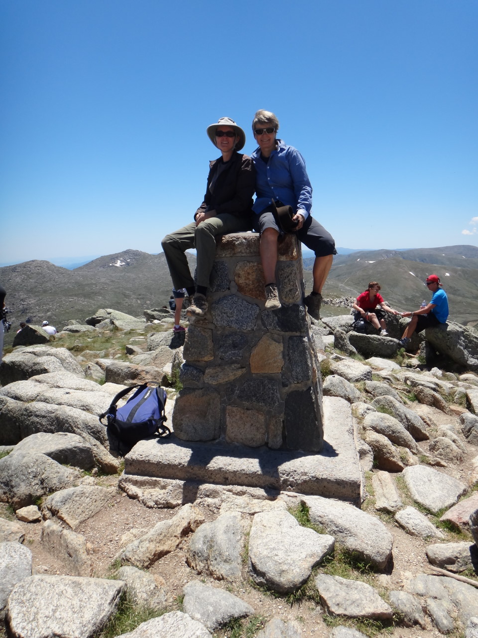
Here we are on top of Australia!! We climbed Mt Kosciuszko twice, once on foot from Thredbo via Eagles Nest and the next day on bicycles via Charlotte Pass.

There are so many wild flowers at the moment and the landscape is just stunning!! One of our old time favourites!! 


Me in front of Seaman's hut, which is an emergency shelter in memory of some lost skiers.

The snow gums are so unique and beautiful!!

On the 8th of January the fire danger reached catastrophic proportions and the National Park was closed. We moved down to Jindabyne to a hotel to wait and re-assess.
Below is a screen shot from the NSW Rural Fire Services with all the fires currently burning in NSW - over 100!!

Jindabyne has some great mountain bike trails along the lake. We spent another two days walking and riding while camping back on the Thredbo river. 

The devastation caused by the 2003 bushfires is still obvious. Much of the area looks like the photo below with dead snow gums and knee-high regrowth (after 10 years!).

The snow gums that survived look as gorgeous as this.


Due to the total fire ban we were not allowed to use our camping stove to cook potatoes. We used the electrical BBQ instead and it took forever!! We both ended up with a tummy ache because we couldn't wait until the potatoes were soft!

It seems that the high temperatures and fire danger are here to stay for a few more weeks. We changed our plans and headed for the coast. The Victorian high country will have to wait!

Wednesday, 7 November 2012

Townsville to Sydney (via Carnarvon Gorge)

As soon as we popped onto the western side of the great dividing range, the landscape became very dry again. Below is the Burdekin River with no water at all.

Emerald's claim to fame (besides the mining) is a giant Van Gogh painting. Can you see Kirsten sitting on a rock underneath it? That's how big it is!

For almost 10 years we have been planning to go to Carnarvon Gorge and now we finally did!! It is just as magic as I imagined!! Sheer sandstone cliffs with lots of deep and narrow gorges and very unique flora and fauna.


We walked all the way to the end of the track at Big Bend, including all the side trips. It was a 24 km day!
Carnarvon Creek at Big Bend below.

There are many side gorges, some very narrow, many of them hard to access. Mickey Creek Canyon and Boowinda Gorge below.


The Cathedral cave is a massive wind-eroded overhang decorated in thousands of years old Aboriginal rock art.

The entrance to the Amphitheatre is only accessible since they built a stairway. It's a hidden 60m deep chamber gouged from the rock by running water. Absolutely amazing!

In the Moss Garden water drips constantly off the wall, supporting a lush carpet of mosses, ferns and liverworts.

The Boolimba bluff is 200m above the Carnarvon Gorge entrance. It usually has a fantastic view, except for when there are bushfires in the vicinity! 

The wildlife at Carnarvon Gorge is just fantastic! The area supports 6 out of 7 Australian glider species!
Besides many birds, roos, frogs and lizards, we saw echidnas, bandicoots, greater gliders, yellow-bellied gliders and even a Freshwater snake or Keelback snake (Tropidonophus mairii).


Carnarvon National Park stretches over 100km and can be accessed from different sides, the Carnarvon Gorge being the most popular section. We decided to check out the Mount Moffatt section as well, because it was sort of on the way (with a detour of only 300km!). It contains many unusual sandstone formations due to the basalt capping on top of the precipice sandstone.

Marlong Arch, ..

the Chimneys, and ...

Cathedral Rock.

The Consuelo Tableland (where Carnarvon Creek starts) with its deep basalt soils and cool, moist conditions supports tall open forest dominated by the majestic silvertop stringybark (Eucalyptus laevopinea). Lucky this place was too inaccessible for logging!!

The track to get up onto the tableland was another 4WD challenge! Excellent fun!


One year post bush fire and a bit of rain and everything is blooming!!

Our camp in Lonesome National Park on the way home.

Roma is said to have the biggest boab tree in QLD! Not easy to hug!