New Zealand has an amazing network of off-road cycling trails and new ones are being built all the time. The amount of money, hard work and negotiations with land owners needed to create these rides must have been staggering. Most trails have great signage, good maps and an incredible amount of purpose built bridges, toilets, picnic tables and shelters/huts. We spent 2.5 months sight-seeing and riding all 13 of the South Island's "Great Rides", resulting in a total of almost 2,000 km and 25,000 m of uphill riding/pushing.
Trail information is available on the official website: http://nzcycletrail.com
Originally we intended to link the trails with on-road riding, which was quickly abandoned once we saw the roads. They are narrow, winding, windy and have no shoulder. Logging trucks, tourist buses and semi-trailers fly past you at 100 km/h with as little as 10 cm between your elbow and the vehicle. It was absolutely terrifying! Lucky NZ has a great network of intercity buses and they do (sometimes reluctantly) take bicycles.

Map Source: The New Zealand Cycle Trails Nga Haerenga : A Guide to New Zealand's 23 Great Rides By Jonathan Kennett
Summary: 150 km, 5 days (incl. 1 day off in Naseby), easy riding.
Attributes: Great food, great accommodation, luggage transport available.
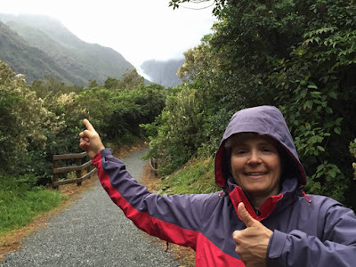
At the trail head in Clyde with Kirsten's family, who joined us for this first ride.


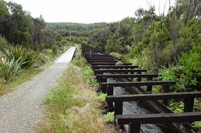
One of the many bridges along the way.

Mountain biking around Naseby on our "rest" day.

On the scenic Taieri Gorge Railway from Pukerangi to Dunedin.

Queenstown Trail
Summary: 4 day-rides, mostly easy riding.
Attributes: Great fun with lots of nice food and wine. Shuttle services available if too drunk to ride home.
Lake Wakatipu near Queenstown....


Out for dinner in Queenstown.


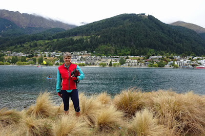


Lake Wakatipu near Queenstown....

... and the Remarkables in the background. What a gorgeous spot!

Out for dinner in Queenstown.


Bike trail from Arrowtown to Gibbston...

... past the famous A.J.Hackett Kawarau Bridge Bungy Jump.

Mountain bike trail to Jacks Point.


We rode up to the Skyline Gondola in Queenstown and then down on Hammy's Track (grade 2) through the Queenstown Bike Park. The grade 5 and 6 tracks looked suicidal!

Kirsten with a well-deserved Moevenpick ice-cream.

Around the Mountains Trail
Summary: approx. 50 km, 1 day (the ride is 3-6 days, but we had mechanical problems and took a shuttle back to Queenstown), easy riding.
Attributes: Remote alpine scenery, lake crossing on steamer great fun, fabulous camping at Mavora Lakes.
The ride starts with a trip on the TSS Earnslaw Steamship from Queenstown to Walter Peak.


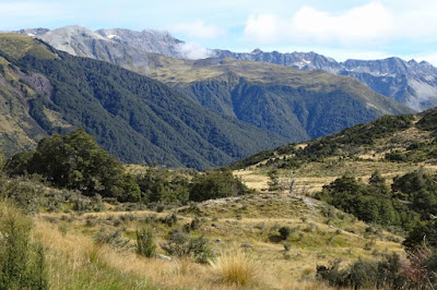
Riding through the Eyre mountains. This was the only uphill section.


The ride starts with a trip on the TSS Earnslaw Steamship from Queenstown to Walter Peak.


Riding through the Eyre mountains. This was the only uphill section.

Fabulous camping spot on South Mavora Lake.

Alps 2 Ocean Trail
Summary: 315 km, 7 days, moderate fitness needed.
Attributes: Stunning scenery and full of surprises.
At Mount Cook Village we waited for two days for the weather to clear. We spent the time with movies, short walks, a ride along the Tasman glacier and making friends with Ed Hillary.

The alpine vegetation is very unique and just gorgeous!


The trail to Ball Hut along the Tasman glacier was supposed to be a bike track, but turned into a walking track on the moraine - very hard to ride without suspension!

Aoraki (Mount Cook) finally revealed itself. It used to be 3,764 m high but lost about 40 m during a rock slide in 1991.

The Alps to Ocean trail starts with a short helicopter ride across the braided river (with the bikes in the back seat). The landscape is so prone to erosion and flooding, that any bridges would be regularly destroyed.


And finally the ride begins!

Lake Pukaki must be one of the most scenic spots in New Zealand!

We decided to ride along the hydro canal to Lake Tekapo and back. The canal is a great fishing spot with brown and rainbow trout, as well as the occasional salmon, which escaped from a farm. I would have loved to put that rainbow trout on the BBQ!

The famous Church of the Good Shepherd in Tekapo, which was about the only thing we liked about the place.

Traffic jam kiwi-style.

Another fantastic camping spot on Lake Ohau. This is why New Zealand is called Aotearoa, "the land of the long white cloud".

Trail overlooking Lake Ohau with the southern alps in the background.

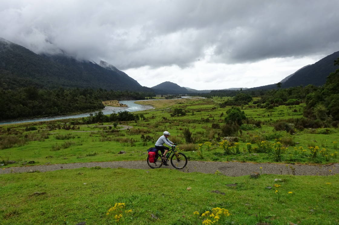
The bike trail follows rivers and lakes towards the coast with stunning scenery along the way.

Kirsten cooking lunch at Duntroon, one of the small towns on the trail.

The Elephant rocks are a fascinating collection of large weathered limestone rocks. Note Kirsten in the centre of the photograph!

Centuries-old Māori rock drawings in a cave.

The landscape is getting greener as we get closer to the coast.

The trail finishes at the beach in Oamaru....

... where Kirsten traded-in her bike.

In order to connect the trails, we caught a bus to Dunedin, the beautiful railway station below.

Clutha Gold Trail
Summary: 80 km, 1 day, easy.
Attributes: Nice ride with lots of history.

An old gold dredge still operating in the Clutha River, one of the fastest flowing rivers in NZ.

These ice-creams are our new favourite calories.


An old gold dredge still operating in the Clutha River, one of the fastest flowing rivers in NZ.


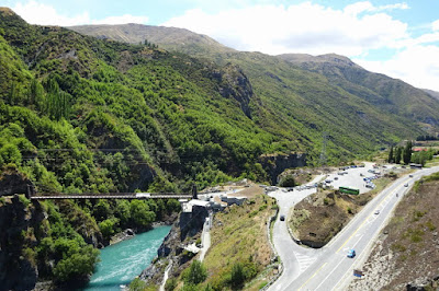
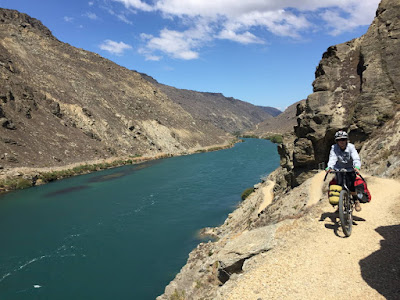
Roxburgh Gorge Trail
Summary: 34 km, 1 day, easy.
Attributes: Great fun, amazing gorge with lots of history and a fun jet-boat ride.
The beginning of the gorge trail is a fun down-hill zig-zag.


A small section of the trail is missing, due to an uncooperative farmer. The gap is filled by a jet-boat service, which was great fun!

Chinese gold washers walked into this gorge and lived in hand-made rock caves/huts, many of which are still intact.


The riding is easy, as long as one has a good sense of balance.

The trail ends in Alexandra where we joined the Millennium Trail back to Clyde. One of the best meals of the trip at Olivers in Clyde.

Sight-seeing in a rental car
We decided to give our legs and bottoms a break and explore areas where there are no rides.
Leaving Queenstown over the mountains towards Wanaka and Hawea.

Fabulous camping at Cameron Flat. You can't get that view for a few dollars a night, unless you're camping!

The down-side? Breakfast with sand flies!

New Zealand Southern Beech Forest is amazing. So many different species of beech, mosses, ferns and lichen!

The blue pools in Makarora River must be some of the clearest water in the world! Unfortunately it was too cold to jump in.


One of the walks in Mount Aspiring National Park was open for bicycles, which we didn't want to miss. We rode from Raspberry Creek to Aspiring Hut, camped there and returned the next day. Another fabulous ride in fantastic weather!

Keas (Nestor notabilis) are the clowns of the mountains. They are great fun to watch until they start stripping the rubber and wiring off the bicycles!

Aspiring Hut looking down the valley from the camping area ....

... and up.


A short side-trip on foot to Rob Roy glacier was well worth it.
On the way to Milford sound we stopped at Lake Te Anau...

... they have interesting street furniture!

The Mirror Lakes are small tarns formed by glaciers.

The mountains in the south-western Fiordland are unbelievably steep and dramatic!

Below is the entrance to the Homer Tunnel, a 1.2 km single-lane tunnel piercing the Darran Mountain range.

Milford Sound in sunshine - a rare event!

West Coast Wilderness Trail
Summary: 139 km, 3 days, easy.
Attributes: Amazing fairy tale forests and wild coastal landscape, very green & wet.
According to the NZ National Institute of Water and Atmospheric Research the We(s)t Coast has a staggering annual rainfall of 4,000 to 10,000 mm (as a comparison, Sydney has around 1,200 mm). Not surprisingly, we had to wait another two days at Franz Joseph for a torrential downpour to subside. Here is the view from our hotel room.


The alpine section of the trail to Kawhaka Pass is gorgeous: green meadows, wild rivers and mystic rainforest.


The landscape along this trail is stunning! Here, the northern section through swamps and finally along the very windy coast.


According to the NZ National Institute of Water and Atmospheric Research the We(s)t Coast has a staggering annual rainfall of 4,000 to 10,000 mm (as a comparison, Sydney has around 1,200 mm). Not surprisingly, we had to wait another two days at Franz Joseph for a torrential downpour to subside. Here is the view from our hotel room.

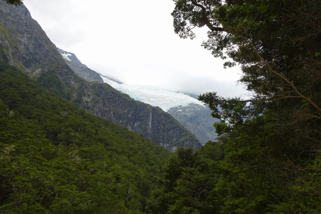
Once the rain stopped we ventured out towards the glacier, which was still hidden in clouds. The Waiho River was muddy, rough and one could hear large boulders being tossed about.

Everything is covered in moss and lichen.


The track to the glacier was closed due to flooding...

... but we managed to get a glimpse of Franz Joseph Glacier in the distance. (I know, it's not really visible on the photograph - it's that blueish fog in the valley.)

The weather forecast was for more rain, so we decided to brave the elements and try our wet-weather gear. Result: we got wet! The riding was still beautiful though!

Hokitika is a small town on the Westcoast, a legacy from the 1864 gold rush and made famous by the novel "The Luminaries" by Eleanor Catton. To us, it seemed grey, rough, unloved and constantly battered by the elements.


Hokitika is a small town on the Westcoast, a legacy from the 1864 gold rush and made famous by the novel "The Luminaries" by Eleanor Catton. To us, it seemed grey, rough, unloved and constantly battered by the elements.

Some of this trail runs along the historic Kaniere water race, which was opened in 1875 to supply water for gold sluicing operations.


The alpine section of the trail to Kawhaka Pass is gorgeous: green meadows, wild rivers and mystic rainforest.

The landscape along this trail is stunning! Here, the northern section through swamps and finally along the very windy coast.


The mouth of the river Grey at Greymouth - very imaginative with names aren't they!

The Old Ghost Road
Summary: 82 km, 3 days, total ascent 3,121 m, hard.
Attributes: Gorgeous and challenging! Alpine and precipitous with fabulous views.
During our bus trip to the trail head, we passed the famous Pancake Rocks at Punakaiki.

I must have walked about 30% of this trail, but what an adventure! When the Kiwis say it's challenging, you better believe it! Steep and narrow tracks, slippery surfaces and precipitous landscape. The challenges never stop until the very end of the track.


Lunch break at Lyell Saddle hut after climbing almost 800 vertical metres.

At 1,300 m the landscape is alpine and the mountains are rocky and steep. Most people ride this trail with mountain bikes and very little gear (they sleep in the huts where only a sleeping bag is needed). We, however, had our panniers full of camping gear and no suspension on our touring bikes. There is not much room for error on this narrow section, so we decided to push the bikes.

We camped next to Ghost Lake Hut, which was fabulous. The hut was crowded, hot and smelly, while we enjoyed the serenity and clean alpine air.


... the moon rise while savouring our dinner.


Ghost Lake Hut is visible on top of the cliff in the middle of the photograph with the tight switch backs of the trail underneath it. Again, too steep, slippery and technical for me to ride.

At least here nobody was riding! Apparently there was no other option than to overcome the 60 vertical metres with steps. There was a sign saying: "If you arrived here by bike, we hope you'll embrace the challenge of scaling these steps as small penance for entering the magical alpine section of The Old Ghost Road." - well said! No pain, no gain!

The trail passes through a huge scree, where a large rockfall occurred during one of the many earth quakes. Yet again, not ideal for our bikes.

One thing we never needed to worry about in New Zealand is drinking water. The small waterfalls, springs and creeks along the steep hills are all safe to drink.


On the third day we followed the Mokihinui River through a gorge and finally to Seddonville. Below one of the many bridges constructed for walkers and cyclists.


During our bus trip to the trail head, we passed the famous Pancake Rocks at Punakaiki.

I must have walked about 30% of this trail, but what an adventure! When the Kiwis say it's challenging, you better believe it! Steep and narrow tracks, slippery surfaces and precipitous landscape. The challenges never stop until the very end of the track.

We started at Lyell and rode north, which is the recommended direction. The first 18 km to Lyell Saddle are through beautiful native forest with a moderate incline - a nice warm-up.


Lunch break at Lyell Saddle hut after climbing almost 800 vertical metres.

At 1,300 m the landscape is alpine and the mountains are rocky and steep. Most people ride this trail with mountain bikes and very little gear (they sleep in the huts where only a sleeping bag is needed). We, however, had our panniers full of camping gear and no suspension on our touring bikes. There is not much room for error on this narrow section, so we decided to push the bikes.

We camped next to Ghost Lake Hut, which was fabulous. The hut was crowded, hot and smelly, while we enjoyed the serenity and clean alpine air.

What a the view from our tent! We watched the sun set and.....

... the moon rise while savouring our dinner.

Ghost Lake is a beautiful protected alpine tarn - unfortunately no swimming.

Ghost Lake Hut is visible on top of the cliff in the middle of the photograph with the tight switch backs of the trail underneath it. Again, too steep, slippery and technical for me to ride.


The trail passes through a huge scree, where a large rockfall occurred during one of the many earth quakes. Yet again, not ideal for our bikes.

One thing we never needed to worry about in New Zealand is drinking water. The small waterfalls, springs and creeks along the steep hills are all safe to drink.


On the third day we followed the Mokihinui River through a gorge and finally to Seddonville. Below one of the many bridges constructed for walkers and cyclists.

Just when you think you made it, there is another challenge through the gorge.

From Seddonville it's a short drive by shuttle bus to Westport.


Great Taste Trail
Summary: 175 km, 2 days, easy to moderate.
Attributes: Very disappointing, especially section from Wakefield to Riwaka along Pigeon Valley Road (70 km gravel road with cars, nothing to see, no food). Coastal section is off road, well signed and easy riding, but I still wouldn't call it the "great taste" trail (except for lunch at Mapua wharf).
Below is the only spot worth a photograph on the inland section of the trail: Motueka River. Note the many weeds and non-native trees.

Much of the coastal riding is through industrial areas and along mud flats....

... with some tame eels along the way.

The only highlights were lunch at a winery one day (10 km unsigned detour from the trail) and at Mapua wharf the next, .....


The salt marsh in Waimea Estuary must have a large number of shore birds at certain times of the year, unless it is too polluted by industrial discharges. There was not much alive when we passed through.

Below is the only spot worth a photograph on the inland section of the trail: Motueka River. Note the many weeds and non-native trees.

Much of the coastal riding is through industrial areas and along mud flats....

... with some tame eels along the way.

The only highlights were lunch at a winery one day (10 km unsigned detour from the trail) and at Mapua wharf the next, .....


..... as well as the ferry trip to Rabbit Island, which separates the shallow Waimea Estuary from the Tasman Bay.

The salt marsh in Waimea Estuary must have a large number of shore birds at certain times of the year, unless it is too polluted by industrial discharges. There was not much alive when we passed through.

Dun Mountain Trail
Summary: 45 km, mountain bike day-ride from Nelson, 878 m climb.
Attributes: Easy rail trail from Nelson to Coppermine Saddle, then very challenging downhill to Maitai Dam, where excellent mountain bike skills are required (unless you want to walk, like me).
The economy in Nelson is based on seafood, horticulture, tourism and forestry. While the town is spread out around mountains and along the coast and therefore not very photogenic, it nevertheless has a nice feel to it and amazing food.


Most of the Nelson and Marlborough regions have been cleared for radiata pine plantations - not so pretty.

Dun Mountain has been named for its dun colour, which is the result of the geological substrate. The unique dense igneous rock was named "dunite" and is composed chiefly of two minerals - olivine (magnesium-iron silicate) and chromite (chromium-iron oxide). The soil lacks plant nutrients and the mountain has allegedly always been devoid of vegetation.


The steepness of the trail is not apparent in the photographs, but the roughness of the surface is.


The economy in Nelson is based on seafood, horticulture, tourism and forestry. While the town is spread out around mountains and along the coast and therefore not very photogenic, it nevertheless has a nice feel to it and amazing food.


European and Australian plants seem to be doing very well in New Zealand. This Eucalyptus globulus was planted in 1857 and must be one of the biggest in the world!


Dun Mountain has been named for its dun colour, which is the result of the geological substrate. The unique dense igneous rock was named "dunite" and is composed chiefly of two minerals - olivine (magnesium-iron silicate) and chromite (chromium-iron oxide). The soil lacks plant nutrients and the mountain has allegedly always been devoid of vegetation.

Coppermine Saddle had some sporadic mining activity between 1850 and 1865, when small deposits of chromite and copper ore were transported to Nelson via tramway.

The steepness of the trail is not apparent in the photographs, but the roughness of the surface is.


Connecting rides to Hanmer Springs (~170 km, 3 days)
The "Great Rides" website recommends the Golden Downs Trail to link rides around Nelson with St Arnaud. It is a sealed back country road through farmland and forestry plantations with a 100 km/h speed limit. What they fail to mention is that it also climbs 1,494 m, which made it a very tough day! St Arnaud is a picturesque alpine town and the gateway to Nelson Lakes National Park. We would have loved to have a rest day here, but unfortunately we coincided with the annual boat show and even the camp ground was full.


False advertising! We never saw any wild Kiwis.

Another trail leads through Rainbow Valley, connecting St Arnaud with Hanmer Springs and the St James Conservation Area. The gravel road was built in the 1950s when the electricity pylons were installed to supply power to the Nelson and Buller regions. It was also the original stock route between Marlborough and Canterbury.

The trail follows the Wairau River through high-country stations to Island Saddle (1,347 m). The landscape changes from green pastures and rocky hills to very arid mountains with scree slopes.


From the pass, the trail follows the Clarence river, where the St James Trail starts.

Due to a forecast of rain with 140 km/h winds, we decided to descend to Hanmer Springs and wait for better weather.

During our rainy "rest" day in Hanmer Springs we tried the local mountain bike trails. It was nice to ride the bikes without luggage - it felt like we were flying!


We had everything organised to begin the St James Trail the next day and then continue north towards Picton. It was not to be: over-night a scrub-fire left Hanmer Springs without power and cut off all access. By the time the issue was resolved, we missed our good weather window and decided to head towards Christchurch instead.
Christchurch
When we first visited Christchurch in 1998 we loved its beautiful old buildings, the lovely parks, cafes and restaurants. That's why we hesitated to go back after the devastating earthquake of 2011, when most of the city centre was destroyed. One of the great rides, however, starts in Christchurch, so we went back. It was heaps more depressing than expected! Every black square in the map below represents a demolished building.

Five years later, the CBD still looks like a war zone: large parking lots where buildings have been removed, .......

.... walls of shipping containers holding up remaining heritage facades ......


The Cardboard Cathedral, a temporary church, was designed by architect Shigeru Ban and seats around 700 people.

Even the statue of Robert Falcon Scott, which was carved by Scott's widow Kathleen Scott, toppled off its plinth and broke in half.


Five years later, the CBD still looks like a war zone: large parking lots where buildings have been removed, .......

.... walls of shipping containers holding up remaining heritage facades ......

... and many buildings cracked, partially in ruins and fenced off.

The Cardboard Cathedral, a temporary church, was designed by architect Shigeru Ban and seats around 700 people.

Even the statue of Robert Falcon Scott, which was carved by Scott's widow Kathleen Scott, toppled off its plinth and broke in half.

The unofficial earthquake memorial of 185 empty white chairs, one for each person killed in the quake.

Most shops operate out of temporary shipping containers, which must get very hot in summer!

Little River Rail Trail
Summary: 50 km, 1 day, easy.
Attributes: Coastal section is nice, high-light was staying in a Silo at Little River.
The trail is totally flat. It first meanders through paddocks and along irrigation channels, then along the coast of Lake Ellesmere and Lake Forsyth.

The trail is totally flat. It first meanders through paddocks and along irrigation channels, then along the coast of Lake Ellesmere and Lake Forsyth.


Our hotel room for the night: a grain silo. A local farmer told us, he thought they were an eye-sore, but we loved the quirkiness of it.

Not much privacy in the shower!


St James Trail
Summary: 68 km, 3 days, some very steep sections, rough surface, lots of water crossings.
Attributes: Fantastic! Remote alpine scenery with lots of rivers, wild horses and even hot springs.
Our third attempt to do this ride was successful and it was worth waiting for the perfect weather! We got a lift back to Mailing Pass car park where we started the ride after a quick detour to the picturesque Lake Tennyson.

The ascent to Mailing Pass (1,308 m) was gentle, but the descent into the Waiau Valley was very steep and slippery!


We only saw two other people during the three days in this remote mountain range. What an amazing alpine landscape for just the two of us!

Our first night camping at Lake Guyon. Kirsten is cooking dinner.


The landscape of the St James Conservation Area is just stunning!

The wild horses of the St James have been roaming the alpine flats since the 1920s and are caught and sold for their stamina, versatility and strength. Not a bad place to live!

What a vista for a lunch break! The trail is visible in the lower right corner of the photograph.

There are many bridges, ......


... and some very steep and rough inclines.

Erosion in New Zealand manifests itself in many different shapes and forms, some of it is quite beautiful.


Nevertheless, we could have spent a few more days on this trail and were sad to leave. Looking back over Peters Pass.

Our third attempt to do this ride was successful and it was worth waiting for the perfect weather! We got a lift back to Mailing Pass car park where we started the ride after a quick detour to the picturesque Lake Tennyson.

The ascent to Mailing Pass (1,308 m) was gentle, but the descent into the Waiau Valley was very steep and slippery!


We only saw two other people during the three days in this remote mountain range. What an amazing alpine landscape for just the two of us!

Our first night camping at Lake Guyon. Kirsten is cooking dinner.


The landscape of the St James Conservation Area is just stunning!


The wild horses of the St James have been roaming the alpine flats since the 1920s and are caught and sold for their stamina, versatility and strength. Not a bad place to live!

What a vista for a lunch break! The trail is visible in the lower right corner of the photograph.

There are many bridges, ......

... river crossings ....


Erosion in New Zealand manifests itself in many different shapes and forms, some of it is quite beautiful.

The second night we camped right next to our very own hot spring! Who needs a hotel room?


The only negative side of this remote and stunning place is the number of sand-flies waiting every morning outside the tent. Any bit of exposed skin was covered in seconds and the bites itch for days!

Nevertheless, we could have spent a few more days on this trail and were sad to leave. Looking back over Peters Pass.

Kaikoura
On the way north we stopped in Kaikoura for a couple of days. The town is famous for the diversity of its marine and coastal ecosystems.


During our coastal walk we saw beautiful rock pools, ....

... interesting rock formations, ...


... colourful seaweed, ...

..... Paua shells, ...

... lazy seals and ....


During the night I woke up because the bed was rocking. No, it wasn't Kirsten having a bad night, the whole room rattled. It is amazing how long it takes the brain to register that it must be an earthquake. A minute later, it was already on the GeoNet website. I just experienced my first 5.0 magnitude earthquake! The same website shows that New Zealand experiences a stunning 20,000 earthquakes every year, 85 of them at magnitude five and over! Maybe we're not moving there after-all!

Queen Charlotte Track
Summary: 72 km, 3 days, very hard, steep up and down, sometimes rough surface.
Attributes: The hardest of all! Lots of pushing due to steep incline. Definitely need mountain bike, full suspension would be great! Nice scenery.
Besides the Otago Rail Trail, this was the busiest of the great rides. Many people walk it rather than cycle, which is probably more sensible. The track is too narrow, too steep and too slippery to ride in many places. On the positive side, the trail access is fabulous (by boat through Marlborough Sound) and there are lots of choices in accommodation.


The Weka (Gallirallus australis) is another of New Zealand's flightless bird species. They are very curious and love shiny things. This one tried to steal Kirsten's bicycle bell, which was hilarious to watch.

Looking towards Kenepuru Sound.

Much of the trail follows the ridge line and .....


Instead of waiting for the ferry to pick us up at Anakiwa, we decided to ride back to Picton.


Cape Farewell is the most northerly point on the South Island. The erosion of the cliffs into fine sand carried on the sea currents creates Farewell Spit, stretching for about 26 km above sea level and another 6 km underwater.


Towards the end of our trip we finally found the Kiwi national symbol: the Silver Fern (Cyathea dealbata). The Māori layed them along tracks for night walking.

One of my favourite dinners in New Zealand: locally farmed and smoked salmon.


After 10 weeks on the South Island, it was time to say goodbye. We were lucky that the sea was calm during the ferry trip, but it was blowing a gale and the ferry was on a constant lean.


Last glimpse of the mainland before heading into Cook Strait.

Besides the Otago Rail Trail, this was the busiest of the great rides. Many people walk it rather than cycle, which is probably more sensible. The track is too narrow, too steep and too slippery to ride in many places. On the positive side, the trail access is fabulous (by boat through Marlborough Sound) and there are lots of choices in accommodation.

The beginning of the track is at Ship Cove where Captain James Cook anchored his ship the Endeavour in 1770 to replenish supplies of food, water and wood.


The first night we stayed at Punga Cove in an A-frame hut. Note the clay stuck to the bicycle tires, which makes the track very slippery.


Most of the time it looked like it was going to rain, but it never did.

The Weka (Gallirallus australis) is another of New Zealand's flightless bird species. They are very curious and love shiny things. This one tried to steal Kirsten's bicycle bell, which was hilarious to watch.

Looking towards Kenepuru Sound.

Much of the trail follows the ridge line and .....

... is clearly visible in the photograph below.

This results in a constant up and down, much of it too steep to ride.

Relaxing at Lochmara Lodge after a tough day. We could not carry enough calories on this trip, ...

... which had the obvious advantage that we could eat what we wanted!

Instead of waiting for the ferry to pick us up at Anakiwa, we decided to ride back to Picton.


Abel Tasman & Kahurangi National Parks
We had a week before we needed to catch the ferry to Wellington, so we rented a car and explored the area around Abel Tasman and Kahurangi National Parks in the north-west of the South Island.
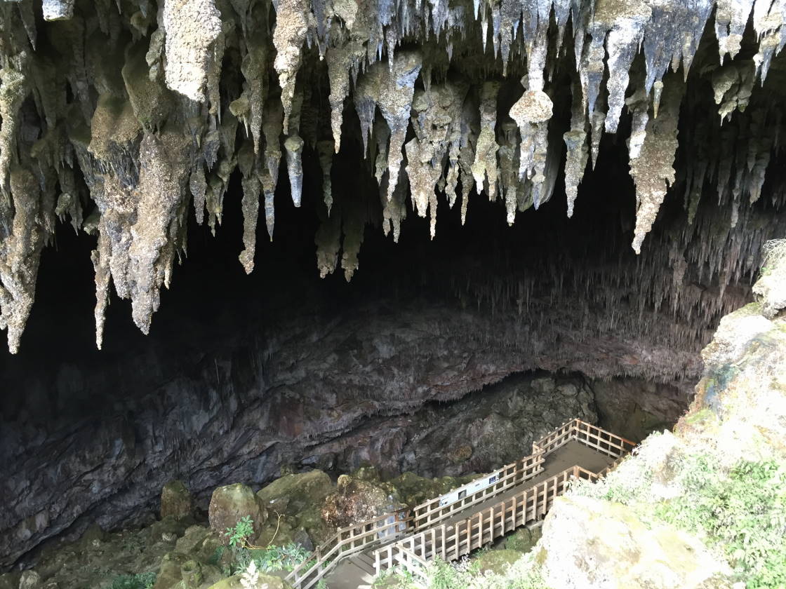
Takaka Hill is made of limestone and has numerous sink holes and caves, some of which can be visited.

The entrance of Rawhiti Cave is significant for its Phytokarst features, where plant growth on stalactites causes them to grow towards the sunlight.

Te Waikoropupū Springs are the largest freshwater springs in New Zealand and contain some of the clearest water ever measured. The average discharge is an amazing 14,000 litres of water per second. I would have loved to snorkel in it, which should be allowed, because the water is wasted anyway, since it flows into the ocean just 4 km to the north.


A very windy place to live, but the sheep don't seem to mind.

Towards the end of our trip we finally found the Kiwi national symbol: the Silver Fern (Cyathea dealbata). The Māori layed them along tracks for night walking.


Back in Picton, we visited the maritime museum where the Edwin Fox was partially restored. She was built in India in 1853 and is the only remaining vessel having brought convicts to Australia and settlers to New Zealand.


After 10 weeks on the South Island, it was time to say goodbye. We were lucky that the sea was calm during the ferry trip, but it was blowing a gale and the ferry was on a constant lean.


Last glimpse of the mainland before heading into Cook Strait.
